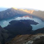
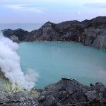
 A “national geopark” is a post de facto designation by UNESCO of a “geographical area” or a transnational geographical area already known to be “of international, regional, and/or national importance” as a candidate geopark. It has not yet been certified as belonging to a regional or the global UNESCO geopark network.
It has been “already inscribed” as a member of some other network; that is, “national geopark” is a sort of floating candidacy that can be attached to any other parkland of interest, after which attachment the parkland qualifies for the designation of geopark. The candidates so designated are termed a “national network for geoparks.”
If it exists in a member nation all geoparks of the regional network in that nation as well as the global network must also belong to it.
A “national geopark” is a post de facto designation by UNESCO of a “geographical area” or a transnational geographical area already known to be “of international, regional, and/or national importance” as a candidate geopark. It has not yet been certified as belonging to a regional or the global UNESCO geopark network.
It has been “already inscribed” as a member of some other network; that is, “national geopark” is a sort of floating candidacy that can be attached to any other parkland of interest, after which attachment the parkland qualifies for the designation of geopark. The candidates so designated are termed a “national network for geoparks.”
If it exists in a member nation all geoparks of the regional network in that nation as well as the global network must also belong to it.
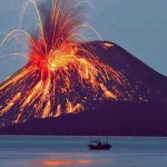
 Some of the networks from which UNESCO national geoparks might be chosen are World Heritage Sites, Agenda 21, Man and the Biosphere Programme. UNESCO also provides a list of recommended geosite types, such as “minerals and mineral resources,” “fossils,” etc.
The national networks (one for each nation) are intended as the bottom level of the bottom-up system. They support national conservation, education, cultural development, research, as well as economic sustainability. There is some effort to control conflict of mandate; for example, Fossils are not allowed to be sold, which practice would favor sustainability, but work against conservation.
For some geoparks, the conflict between geotourist development and the conservation of archaeological sites is a severe one, reaching the law courts. As with the other levels of geopark, the parks are subject to review for recertification every four years.
Some of the networks from which UNESCO national geoparks might be chosen are World Heritage Sites, Agenda 21, Man and the Biosphere Programme. UNESCO also provides a list of recommended geosite types, such as “minerals and mineral resources,” “fossils,” etc.
The national networks (one for each nation) are intended as the bottom level of the bottom-up system. They support national conservation, education, cultural development, research, as well as economic sustainability. There is some effort to control conflict of mandate; for example, Fossils are not allowed to be sold, which practice would favor sustainability, but work against conservation.
For some geoparks, the conflict between geotourist development and the conservation of archaeological sites is a severe one, reaching the law courts. As with the other levels of geopark, the parks are subject to review for recertification every four years.


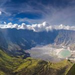


 A global geopark is one that has been certified to the fullest extent, and is therefore a member of UNESCO’s global network of geoparks. It is per se also a member of a regional geopark network and also a member of a national geopark network, if its nation has one, or a transnational geopark.
A certification is good for four years, after which it must be certified again. In the language of certification, a recertified global geopark is termed a “green-card geopark.”[x] If a geopark fails recertification it is given two years to pass, in which it is a “yellow-card geopark.”[xi] After two years if it is still unrecertified it is a “red-card geopark;” that is, no longer a geopark, and is removed from connection with or concern by UNESCO.
To reapply, it must start the application over. Recertified geoparks do not have to keep the same borders; only a portion may be recertified.
A global geopark is one that has been certified to the fullest extent, and is therefore a member of UNESCO’s global network of geoparks. It is per se also a member of a regional geopark network and also a member of a national geopark network, if its nation has one, or a transnational geopark.
A certification is good for four years, after which it must be certified again. In the language of certification, a recertified global geopark is termed a “green-card geopark.”[x] If a geopark fails recertification it is given two years to pass, in which it is a “yellow-card geopark.”[xi] After two years if it is still unrecertified it is a “red-card geopark;” that is, no longer a geopark, and is removed from connection with or concern by UNESCO.
To reapply, it must start the application over. Recertified geoparks do not have to keep the same borders; only a portion may be recertified.