
 Etymology
The name “Merapi” comes from the abbreviation “meru” (= mountain) and “api”, so the name “merapi” actually means “volcano”. In old manuscripts, Merapi was once known as Mandrageni, and also Candrageni.
Geology
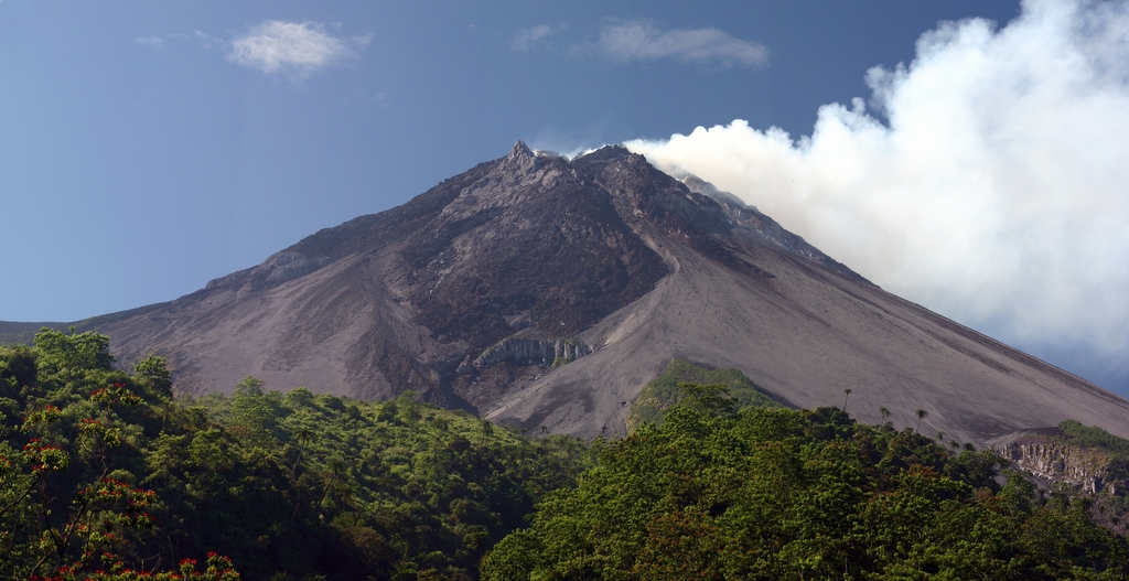
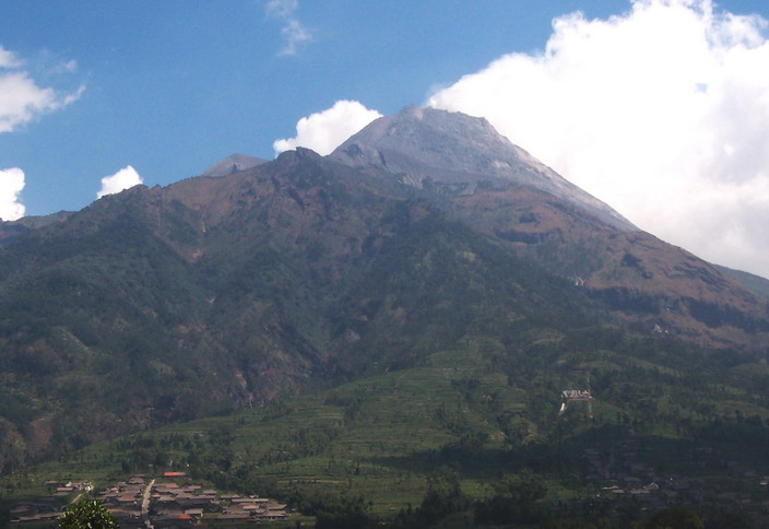
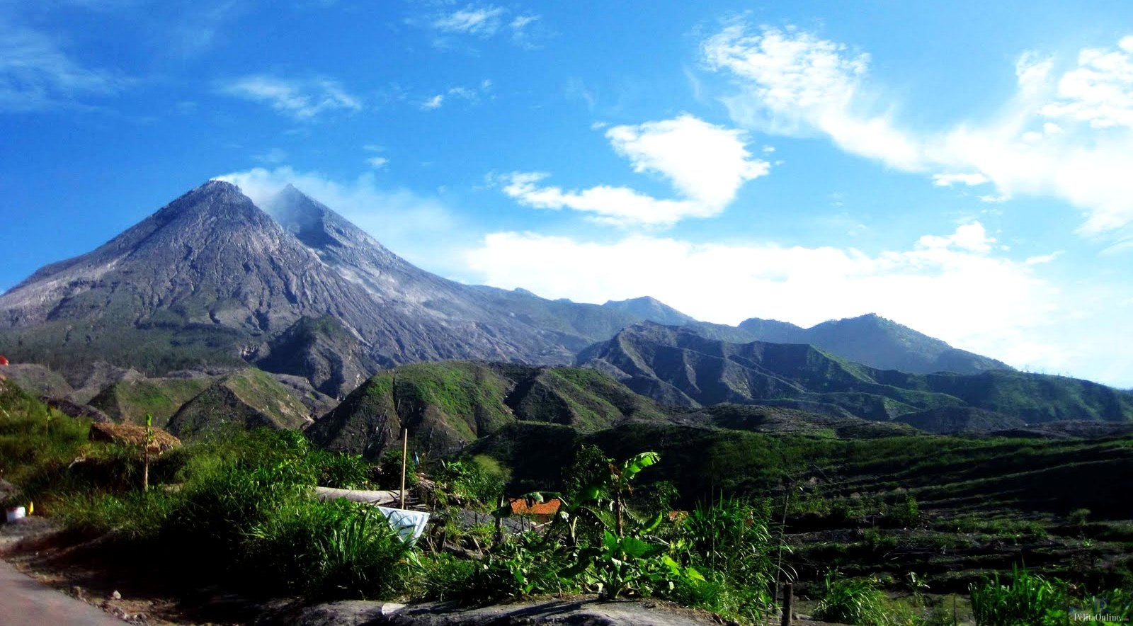
This mountain is the youngest mountain in a series of volcanoes that point south from Mount Ungaran, Mount Merbabu, and Mount Merapi. This mountain was formed due to activity in the subduction zone of the Indo-Australian Plate which moves down the Eurasian Plate causing volcanic activity along the central part of Java Island. The current peak is not overgrown with vegetation due to high volcanic activity. This peak grows on the southwest side of the older peak of Batulawang.
 New Merapi
The fourth period of Merapi activity which is currently known as the New Merapi period (2000 years ago to present), where the cone of the peak of Merapi, known as Mount Anyar, was formed in the former Bubrah Market crater starting around 2000 years ago.
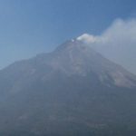
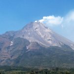
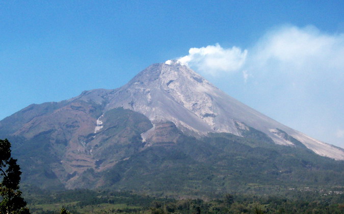
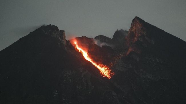
The characteristics of the eruptions since 1953 are the lava rush to the top of the crater accompanied by the periodic collapse of the lava dome and the formation of hot clouds (nuée ardente) that can slide down the slopes of the mountains or vertically upwards. This type of Merapi eruption generally does not produce an explosive sound but a hiss. The dome of the peak that existed until 2010 was the result of a process that had been ongoing since the 1969 gas eruption.
Geologists in 2006 detected a giant chamber beneath Merapi containing mud-like material that “significantly inhibits earthquake shock waves”. Scientists estimate the material is magma. This magma pocket is part of a formation formed by the plunging of the Indo-Australian Plate under the Eurasian Plate.
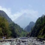
 Merapi as the upstream river
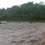
As a mountain with high volcanic activity, Mount Merapi has many sources of water discharge as a result of the pressure of water vapor from the earth. There are many rivers which then form canyons on the slopes and then form sedimentary plains of volcanic material. These rivers lead mainly to the southeast (Klaten), then south (Yogyakarta) to west (Magelang), supplying water to the Bengawan Solo watersheds (southeast), Opak River (south), and the Progo River (southwest and west).
There are rivers that form the canyon as a path for the movement of pyroclastic and lava material, such as Kali Woro (southeast, Klaten Regency), Kali Gèndhol (south, near the Sleman-Klaten border), Kali Bebeng (south, Sleman), Kali Boyong ( south, Sleman), Kali Krasak (southwest, Magelang), and Kali Pabelan (west, Magelang). To these rivers a lava retaining system has been built in the form of a Sabo dam. Apart from rivers, there are also water sources (umbul) which are used for bathing and irrigation for rice fields.

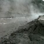
 Eruption in 2010
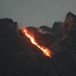
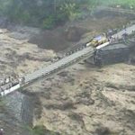
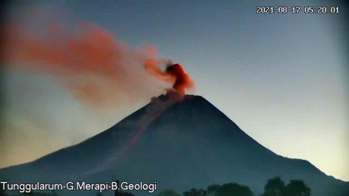
The first eruption occurred at around 17.02 WIB on 26 October. At least there were three eruptions. The eruption spewed volcanic material about 1.5 km high and was accompanied by the release of hot clouds that hit Kaliadem, Kepuharjo Village, Cangkringan District, Sleman. and killed 43 people, plus a baby from Magelang who died of respiratory problems.
Starting October 28, Mount Merapi spewed incandescent lava that appeared almost simultaneously with the release of hot clouds at 19.54 WIB. Furthermore, the hotspots began to be observed resting on the summit on November 1, marking a new phase that the magma has reached the crater hole.
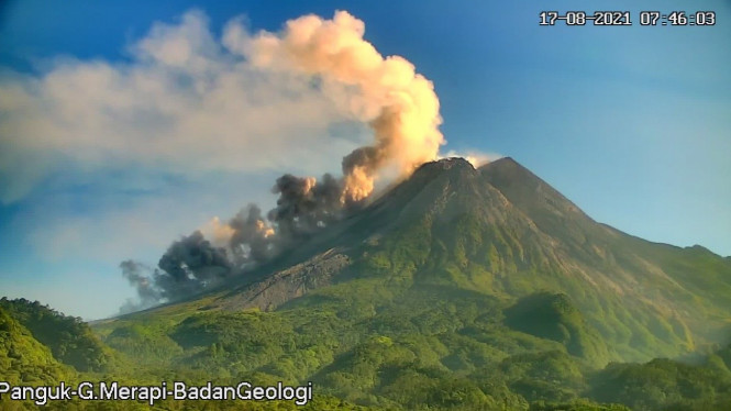
Increased activity of lava flows and hot clouds since November 3. The explosive eruption in the form of a large eruption began on the morning of Thursday, November 4, 2010, resulting in a cloud column as high as 4 km and a burst of hot clouds in various directions at the foot of Merapi.
 Furthermore, since around three o’clock in the afternoon, the eruption occurred continuously until evening and reached its peak in the early hours of Friday, November 5, 2010.
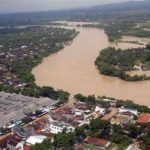
This series of eruptions and rumbling sounds could be heard up to Yogyakarta City (about 27 km from the summit), Magelang City, and the center of Wonosobo Regency (50 km distance). Gravel and sand rains reached the northern part of Yogyakarta City, while heavy volcanic ash rain hit Purwokerto and Cilacap. During the day, volcanic ash is known to have reached Tasikmalaya, Bandung and Bogor.
The November 5 strong eruption was followed by high activity for about a week, before then there was a slight decrease in activity, but the safety status remained “Caution”. On 15 November 2010 the hazard radius limit for Magelang District was reduced to 15 km and for the other two Central Java districts to 10 km. Only for Kab. Sleman, which still has a 20 km hazard radius.
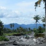
 2018-2020 Activities
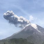
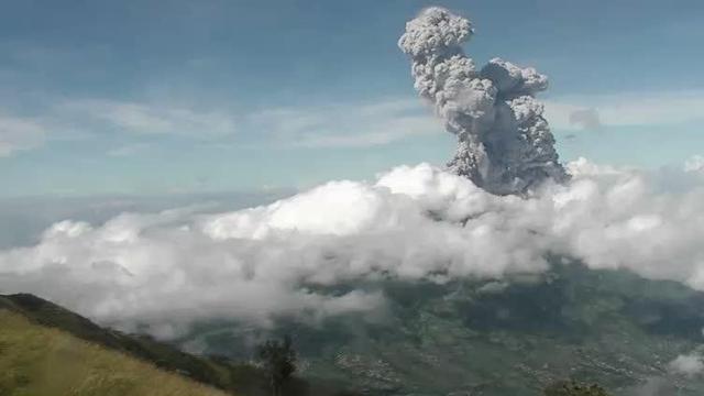
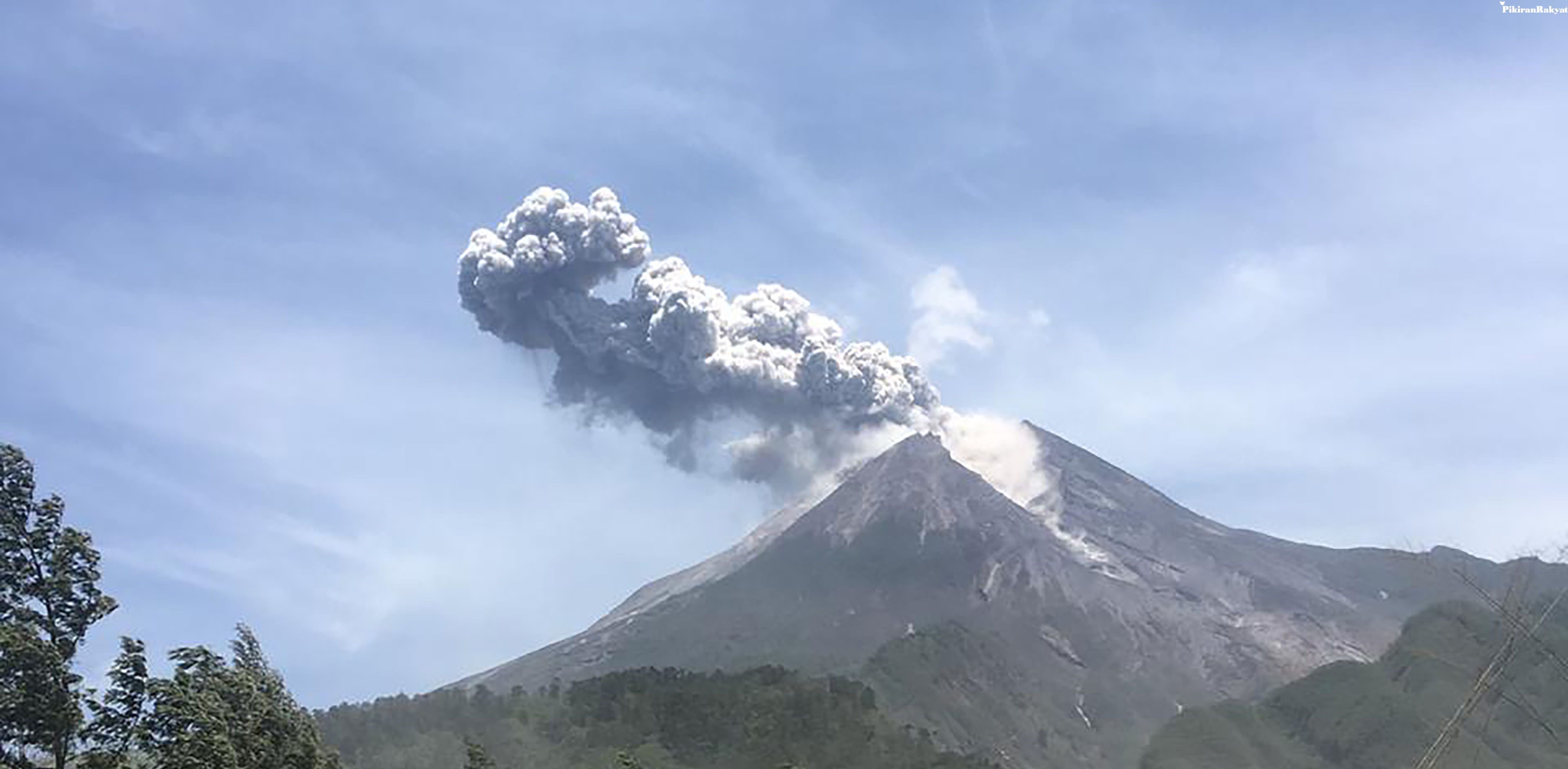
This mountain has shown an increase in volcanic activity since Friday, 11 May 2018, at 07.30 WIB. Even though its status is normal, Mount Merapi makes a roar with smoke soaring. This phreatic (blowing) type eruption generates smoke as high as 5,500. There were no reports of deaths or injuries. Light ash rain fell on the western slope.
Since that incident, PPGM began monitoring Merapi’s increasing activity, so that on May 21, 2018, at 23.00 WIB the status of Merapi was raised from normal active to alert. This status was never lowered since then, which resulted in the closure of climbing access to Mount Merapi.
Thursday, 24 May 2018, Mount Merapi erupted again with smoke as high as 6,000 meters. Ash rain flushed the western region of the mountain, namely Magelang Regency and even reached Kebumen Regency which is more than 40 kilometers away.
Mount Merapi erupted again on Friday, June 1 2018 at 08.20 WIB with a duration of 2 minutes. The eruption column of Mount Merapi is about 6,000 meters from the peak, or about 8,968 meters above sea level to the northwest. Report of ash rain to Salatiga and Semarang Regency.
 After being relatively stable in 2019, on Saturday, 28 March 2020, at 19.25 WIB, Mount Merapi erupted. In this eruption, the character of the eruption began to mix with explosive eruptions (accompanied by explosions and throws of large material). On Sunday, 29 March 2020, at 00.15 WIB, Mount Merapi erupted with the eruption column height measuring 1500 meters above the peak or 4,468 meters above sea level. The eruption is recorded on a seismogram with a maximum amplitude of 40 mm with a duration of approximately 2 minutes 30 seconds.
On April 10, 2020, at 09.10 WIB, Mount Merapi erupted with an eruption column height measuring 3000 meters from the top of the summit crater. The eruption was recorded on a seismogram with an amplitude of 75 mm and a duration of 103 seconds. Wind direction when erupted to the Northwest.
On June 21, 2020, at 09:13 WIB, Mount Merapi erupted again with an eruption column height of 6000 meters from the top of the crater of the mountain’s peak. The eruption was recorded on a seismogram with an amplitude of 75 mm and a duration of 328 seconds. When the first eruption occurred, BPPTKG monitored the wind direction to the west. At the second eruption, monitored amplitude of 75 mm and duration of 100 seconds. The column height at this second eruspy is not observed.
The BNPB Operations Control Center received a report from the local BPBD regarding the distribution of ash. The distribution of volcanic ash rain from the eruption of Mount Merapi which was observed at 09.56 occurred in several villages in two Srumbung Districts (Kaliurang, Kemiren, Srumbung, Banyuadem, Kalibening and Ngargosoko Villages) and Dukun District (Ngargomulyo and Keningar Villages).
On Thursday, 5 November 2020, at 12.00 WIB, BPPTKG upgraded the status of Mount Merapi from Waspada (Level II) to Alert (Level III) because volcanic activity on Mount Merapi is thought to have continued to erupt that endanger the community. This is based on the chronology of data from monitoring volcanic activity, namely first after the explosive eruption of 21 June 2020, internal seismicity, namely VA, shallow volcanic (VB) and multi-phase (MP) began to increase.
Since October 2020 the seismicity has intensified. On November 4, 2020 the average earthquake VB was 29 times / day, MP 272 times / day, avalanche (RF) 57 times / day, gusts (DG) 64 times / day. However, there was no indication of the formation of new lava domes. The earthquake and deformation were still increasing and the BPPTKG warned of the danger of gliding hot clouds as far as 5 kilometers from the top of the mountain.
 Newest 2021 Activities
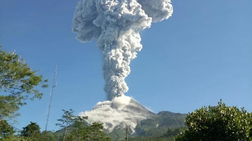
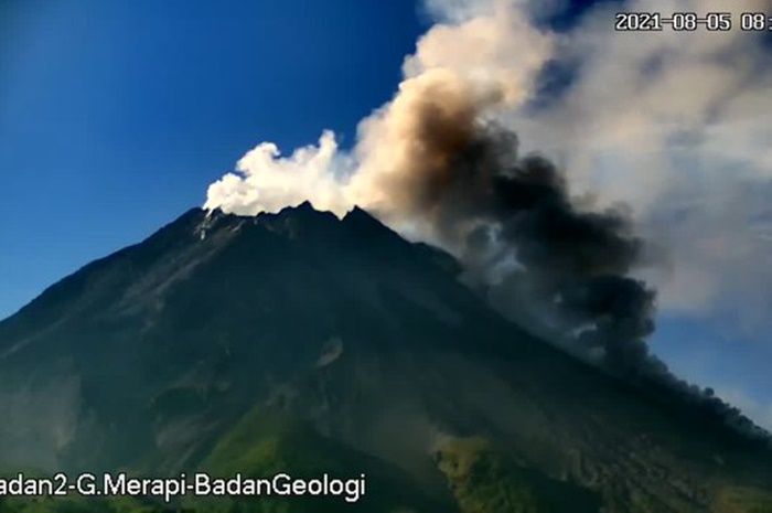
The eruption of Mount Merapi this afternoon (August 28, 2021) caused a number of villages in Magelang Regency, Central Java, to be showered with ash. Light ash rain was reported to have occurred in nine villages spread across Srumbung and Salam sub-districts.
 Based on information from the public, there has been a thin ash rain due to hot clouds falling from Mount Merapi. Ash rain occurred in several KRB (disaster-prone areas) Merapi and surrounding areas, Saturday (28/8/2021).
 The ash rain was reported to have occurred in Srumbung sub-districts covering the villages of Kradenan, Srumbung, Kaliurang and Kemiren. In addition, ash rain also occurred in the villages of Banyuadem, Jerukagung and Ngablak. Meanwhile in Salam District, it includes Sucen and Kadiluwih Villages. The public is advised to remain calm and vigilant.
 Previously reported, Mount Merapi erupted again and spewed hot clouds this afternoon. Based on BPPTKG data, the distance of Mount Merapi’s hot clouds glide this time reaches 3 kilometers. Hot clouds from Merapi avalanches occurred on August 28, 2021 at 16.20 WIB.
This volcanic eruption, which is located on the border of Central Java and the Special Region of Yogyakarta (DIY), was recorded on a seismogram with an amplitude of 60 millimeters and a duration of 234 seconds. The weather is foggy and the estimated glide distance is 3,000 meters to the southwest. Until now (29 August 2021) BPPTKG has still determined the status of Mount Merapi at the Alert level since 5 November 2020.
 Vegetation
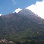
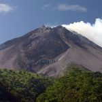
Mount Merapi at the top is never overgrown with vegetation due to high activity. The types of plants at the top are of the typical alpine type of Javanese mountains, such as rhododendrons and Javanese edelweiss. Slightly down there are bamboo forests and tropical mountain vegetation. The mountainous tropical rain forest on the southern slopes of Merapi is home to one of the rare species of the Vanda tricolor ‘Merapi’ orchid.
The southwestern slopes of Merapi, especially below 1,000 m, are the origin of two national superior salak cultivars, namely ‘Pondoh’ and ‘Nglumut’ salak.
Hiking routes
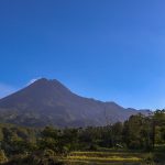
Mount Merapi is a popular climbing object. because this mountain is a very enchanting mountain. The most common and closest climbing route is through the north side of Sélo, Boyolali Regency, Central Java, to be precise in the villages of Plalangan, Selo, Boyolali. This village is located between Mount Merapi and Mount Merbabu. The hike through Selo takes about 4-5 hours to the top.
 Another popular route is through Kaliurang, Pakem District, Sleman Regency, Yogyakarta on the south side. This path is more steep and takes about 6-7 hours to the top. Another alternative route is through the northwest side, starting from Sawangan, Magelang Regency, Central Java, and through the southeast side, from the direction of Deles, Kemalang District, Klaten Regency, Central Java.
Mrapen eternal flame
Mrapen eternal flame is a complex located in Manggarmas village, Godong sub-district, Grobogan regency, Central Java. This area is located on the main road of Purwodadi – Semarang, 26 km from the city of Purwodadi. The Mrapen eternal fire complex is a natural geological phenomenon in the form of natural gas emitting from the ground which is ignited by fire, creating a fire that never goes out even though it rains.
Many major events take the fire from the Mrapen eternal fire complex as the source of the torch, for example the Ganefo I international sports party on November 1, 1963.The eternal flame from Mrapen is also used to light the torch of the National Sports Week (PON) starting from PON X in 1981, POR PWI in 1983 and HAORNAS. The eternal flame of Mrapen is also used for the torch for Vesak ceremonies.
Apart from the eternal fire, in the complex there is also a pool with boiling water which is said to be used to treat skin diseases, as well as a heavy stone which is said to be if someone can lift it, the one who lifts it will get what he wants.