
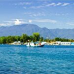
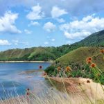
 West Papua (Indonesian: Papua Barat), formerly Irian Jaya Barat (West Irian), is an Indonesian province located in Indonesia Papua. It covers most of the two western peninsulas of the island of New Guinea: the eastern half of the Bird’s Head Peninsula (or Doberai Peninsula) and the whole of the Bomberai Peninsula, along with nearby smaller islands. The province is bordered to the north by the Pacific Ocean, to the west by Southwest Papua Province, the Halmahera Sea and the Ceram Sea, to the south by the Banda Sea, and to the east by the province of Central Papua and the Cenderawasih Bay. Manokwari is the province’s capital and largest city.
 The provincial area now includes the eastern part of the Doberai Peninsula (Bird’s Head Peninsula) and the whole of the Bomberai Peninsula to the south. In the north, the province is bordered by the Pacific Ocean, in the west by Southwest Papua, North Maluku province and Maluku province, in the east by Cenderawasih Bay, in the south by the Ceram Sea and in the southeast by Central Papua Province. The southeastern boundary of West Papua is almost the same as the Afdeling boundary (“part”) West Nieuw-Guinea (“West New Guinea”) in the Dutch East Indies. Since the creation of the new Southwest Papua Province, the residual West Papua Province consists of only seven regencies.
West Papua is located between 0–4 degrees South Latitude and 124–132 degrees East Longitude, just below the equator with an altitude of 0–100 m (0–328 ft) above sea level. The area of West Papua before the creation of Southwest Papua Province was 99,398.26 km2 (38,377.88 sq mi), and is currently about 60,275.33 km2 (23,272.44 sq mi).
The climate in West Papua also tends to be the same as the climate in the Papua Province, which is tropical with rainfall varying in each region.
The land condition in West Papua is almost the same as the Papua Province where the surface is in the form of cliffs and slopes. The types of soil in West Papua are latosol, resina, red and yellow medeteren, podsol, red yellow podsolic, gray red podsolic, litosol, alluvia, gray hydromorph.
The provincial area now includes the eastern part of the Doberai Peninsula (Bird’s Head Peninsula) and the whole of the Bomberai Peninsula to the south. In the north, the province is bordered by the Pacific Ocean, in the west by Southwest Papua, North Maluku province and Maluku province, in the east by Cenderawasih Bay, in the south by the Ceram Sea and in the southeast by Central Papua Province. The southeastern boundary of West Papua is almost the same as the Afdeling boundary (“part”) West Nieuw-Guinea (“West New Guinea”) in the Dutch East Indies. Since the creation of the new Southwest Papua Province, the residual West Papua Province consists of only seven regencies.
West Papua is located between 0–4 degrees South Latitude and 124–132 degrees East Longitude, just below the equator with an altitude of 0–100 m (0–328 ft) above sea level. The area of West Papua before the creation of Southwest Papua Province was 99,398.26 km2 (38,377.88 sq mi), and is currently about 60,275.33 km2 (23,272.44 sq mi).
The climate in West Papua also tends to be the same as the climate in the Papua Province, which is tropical with rainfall varying in each region.
The land condition in West Papua is almost the same as the Papua Province where the surface is in the form of cliffs and slopes. The types of soil in West Papua are latosol, resina, red and yellow medeteren, podsol, red yellow podsolic, gray red podsolic, litosol, alluvia, gray hydromorph.
 The mountains in West Papua include the Arfak Mountains (2,940 m (9,646 ft)) in Arfak Mountains Regency, the Fak-Fak Mountains in Fak-Fak Regency, Mount Fudi (1,280 m (4,199 ft)) in Fak-Fak Regency, Kumafa Mountains in Fak-Fak Regency, Mount Togwomeri (2,680 m (8,793 ft)) in Manokwari Regency, Mount Wasada (1,070 m (3,510 ft)) in Manokwari Regency, Mount Wiwi (1,130 m (3,707 ft)) in Manokwari Regency.
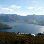
Lakes in West Papua include Anggi Giji Lake in Manokwari Regency, Anggi Gita Lake in Manokwari Regency, Lake Yamur in Manokwari Regency.
The province is rich in karst areas. Many of these areas remain unexplored from a speleological point of view. Among the most important caves explored, there are the Lomo Longmot (360 metres deep) and Lomo Iono Besar (315 metres deep), respectively the second and fourth caves for depth in Indonesia. These caves were explored in the 1990s by a French speleology expedition team in the Lina Mountains region, Irameba Village, Anggi District, Manokwari Regency. Recently the karst system of the Aouk-Kladuk river has been explored.
The mountains in West Papua include the Arfak Mountains (2,940 m (9,646 ft)) in Arfak Mountains Regency, the Fak-Fak Mountains in Fak-Fak Regency, Mount Fudi (1,280 m (4,199 ft)) in Fak-Fak Regency, Kumafa Mountains in Fak-Fak Regency, Mount Togwomeri (2,680 m (8,793 ft)) in Manokwari Regency, Mount Wasada (1,070 m (3,510 ft)) in Manokwari Regency, Mount Wiwi (1,130 m (3,707 ft)) in Manokwari Regency.
Lakes in West Papua include Anggi Giji Lake in Manokwari Regency, Anggi Gita Lake in Manokwari Regency, Lake Yamur in Manokwari Regency.
The province is rich in karst areas. Many of these areas remain unexplored from a speleological point of view. Among the most important caves explored, there are the Lomo Longmot (360 metres deep) and Lomo Iono Besar (315 metres deep), respectively the second and fourth caves for depth in Indonesia. These caves were explored in the 1990s by a French speleology expedition team in the Lina Mountains region, Irameba Village, Anggi District, Manokwari Regency. Recently the karst system of the Aouk-Kladuk river has been explored.  In general, when viewed from the perspective of cultural characteristics, livelihoods, and patterns of life, indigenous Papuans in West Papua can be divided into two major groups: highlander (inland or mountainous) Papuans, which are non-Austronesian, and coastal Papuans, which are Austronesian (italicized above). Though centuries of interaction have caused both groups to have mixed and influenced each other.
The remaining population is mostly migrants from other parts of Indonesia, with the largest group of migrants from Sulawesi, such as Buginese, Makassarese, Minahasan, Torajan, Butonese, followed by Javanese, and Moluccans.
The population of West Papua Province embraces different religions. Data in 2022 showed that the largest percentage of religious believers were Protestant Christians (54.17%), then Islam (36.74%), Catholic Christians (8.71%), Hinduism (0.19%), and Buddhism (0.19%)
In the province, the city of Manokwari has come to be known as the “Gospel City”, as it is directly inland from Mansinam Island where the first European missionaries of Carl Ottow and Johann Geissler, under the initiative of Ottho Gerhard Heldring to reached Papua.
In general, when viewed from the perspective of cultural characteristics, livelihoods, and patterns of life, indigenous Papuans in West Papua can be divided into two major groups: highlander (inland or mountainous) Papuans, which are non-Austronesian, and coastal Papuans, which are Austronesian (italicized above). Though centuries of interaction have caused both groups to have mixed and influenced each other.
The remaining population is mostly migrants from other parts of Indonesia, with the largest group of migrants from Sulawesi, such as Buginese, Makassarese, Minahasan, Torajan, Butonese, followed by Javanese, and Moluccans.
The population of West Papua Province embraces different religions. Data in 2022 showed that the largest percentage of religious believers were Protestant Christians (54.17%), then Islam (36.74%), Catholic Christians (8.71%), Hinduism (0.19%), and Buddhism (0.19%)
In the province, the city of Manokwari has come to be known as the “Gospel City”, as it is directly inland from Mansinam Island where the first European missionaries of Carl Ottow and Johann Geissler, under the initiative of Ottho Gerhard Heldring to reached Papua.
 They were under permission from Tidore Sultanate, who facilitated them with a ship, and connected them with his vassals in the area, like the later Salawati king of Muhammad Amminudin Arfan as their local guide. They entered Papua at Mansinam Island, near Manokwari on 5 February 1855. The date has become a significant local Christian holiday known as “Gospel Day”, celebrated annually across Indonesian Papua.
Indonesian is the official language in the Papua Barat province, just like other provinces in Indonesia. All road signs and documents released by the provincial government are written in Indonesian. However, Papuan Malay is used as the lingua franca of the province, both as a trade language and in inter-ethnic communication. Papuan Malay is considered to be similar to Ambonese Malay and Manado Malay language, and is mutually intelligible with Indonesian though it has been highly influenced by local languages.
The number of local languages used by the native peoples of the Papua Barat province reaches 34 consisting of approximately 14 Austronesian languages and 20 Papuan languages.
Regional languages in the Papua Barat province are threatened with extinction, because there are fewer and fewer users. Most regional languages in the province are threatened with extinction, if not immediately documented and preserved. The threat of extinction is due to economic, educational and political problems. The indigenous Papuans who transact on the market will use Indonesian, because the buyers or sellers are migrants or they speak a different Papuan language. The need for children to use Indonesian daily and the lack of education in schools about regional languages largely contributes to their disuse and extinction.
They were under permission from Tidore Sultanate, who facilitated them with a ship, and connected them with his vassals in the area, like the later Salawati king of Muhammad Amminudin Arfan as their local guide. They entered Papua at Mansinam Island, near Manokwari on 5 February 1855. The date has become a significant local Christian holiday known as “Gospel Day”, celebrated annually across Indonesian Papua.
Indonesian is the official language in the Papua Barat province, just like other provinces in Indonesia. All road signs and documents released by the provincial government are written in Indonesian. However, Papuan Malay is used as the lingua franca of the province, both as a trade language and in inter-ethnic communication. Papuan Malay is considered to be similar to Ambonese Malay and Manado Malay language, and is mutually intelligible with Indonesian though it has been highly influenced by local languages.
The number of local languages used by the native peoples of the Papua Barat province reaches 34 consisting of approximately 14 Austronesian languages and 20 Papuan languages.
Regional languages in the Papua Barat province are threatened with extinction, because there are fewer and fewer users. Most regional languages in the province are threatened with extinction, if not immediately documented and preserved. The threat of extinction is due to economic, educational and political problems. The indigenous Papuans who transact on the market will use Indonesian, because the buyers or sellers are migrants or they speak a different Papuan language. The need for children to use Indonesian daily and the lack of education in schools about regional languages largely contributes to their disuse and extinction.
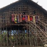

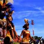
 The traditional house of people in this province is called Rumah Kaki Seribu (Thousand Legs House) because it is a stilt house with many pillars which is the reason for its name. The roof was made of straw or sago leaves and wood as its pillars. The pillars are useful for protecting the inhabitants from enemies and the threat of people with evil intentions or black magic. Traditionally to warm the occupants, hot ember will be put below the house.
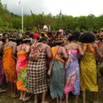
The traditional clothes in the West Papua region are named Serui. Not much different from traditional clothing in Papua, the form of clothing is almost the same for both men and women. They wear clothes and lower body coverings in the same shape. They also wear ornaments on the chest and head in the form of necklaces, bracelets, ornaments of birds of paradise on the other parts of the head. Equipment worn by men at weddings usually have the groom holding a shield such as an arrow or tombah to fulfill the Papuan custom.
Another West Papuan traditional clothing is called Ewer. This garment is purely made from natural ingredients, namely dried straw. With the progress and influence of modernization, these traditional clothes were then equipped with cloth for their superiors. The following is a picture of the traditional Ewer clothing typical of West Papuans. At present, natural materials such as straw or dry fiber are only used as skirts for women. The skirt is made by taking plant fibers and arranging them using a rope at the top. This skirt is made with two layers, the inner layer is knee-length, and the outer layer is shorter. To strengthen skirt ties, belts made of bark are used in such a way. Usually the carving motif is not complicated, namely the gingham with a geometric arrangement.
The traditional house of people in this province is called Rumah Kaki Seribu (Thousand Legs House) because it is a stilt house with many pillars which is the reason for its name. The roof was made of straw or sago leaves and wood as its pillars. The pillars are useful for protecting the inhabitants from enemies and the threat of people with evil intentions or black magic. Traditionally to warm the occupants, hot ember will be put below the house.
The traditional clothes in the West Papua region are named Serui. Not much different from traditional clothing in Papua, the form of clothing is almost the same for both men and women. They wear clothes and lower body coverings in the same shape. They also wear ornaments on the chest and head in the form of necklaces, bracelets, ornaments of birds of paradise on the other parts of the head. Equipment worn by men at weddings usually have the groom holding a shield such as an arrow or tombah to fulfill the Papuan custom.
Another West Papuan traditional clothing is called Ewer. This garment is purely made from natural ingredients, namely dried straw. With the progress and influence of modernization, these traditional clothes were then equipped with cloth for their superiors. The following is a picture of the traditional Ewer clothing typical of West Papuans. At present, natural materials such as straw or dry fiber are only used as skirts for women. The skirt is made by taking plant fibers and arranging them using a rope at the top. This skirt is made with two layers, the inner layer is knee-length, and the outer layer is shorter. To strengthen skirt ties, belts made of bark are used in such a way. Usually the carving motif is not complicated, namely the gingham with a geometric arrangement.
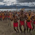
 As West Papua consists of many tribes, there are many traditional dances from each tribe. However, a commonly shared dance among the Arfak tribes was what Ottow and Geissler, 19th century German missionaries in the area, called the Tumbu Tanah Dance (ground stomp dance). Previously, Hattam people called the dance Ibihim, Isim for the Moile people, Mugka for the Meyakh people, and Mayonhora for the Sough people.
The dance consists of two basic movements called bihim ifiri kai cut, which is hopping while stomping the ground, imitating cuscus and namdur, and yam, which is the interlocking of dancers arms at the elbows. Then the dancers will form three formations imitating snake, jey/srem: a long line; ikrop: a half circle; and nimot: a full circle. The dance will be accompanied by music and singing either diun (songs about praising ancestors), nihet duwei (situational songs depending on the purpose of the dance), or isiap (encouraging shouts by the dancers to be ready).
As West Papua consists of many tribes, there are many traditional dances from each tribe. However, a commonly shared dance among the Arfak tribes was what Ottow and Geissler, 19th century German missionaries in the area, called the Tumbu Tanah Dance (ground stomp dance). Previously, Hattam people called the dance Ibihim, Isim for the Moile people, Mugka for the Meyakh people, and Mayonhora for the Sough people.
The dance consists of two basic movements called bihim ifiri kai cut, which is hopping while stomping the ground, imitating cuscus and namdur, and yam, which is the interlocking of dancers arms at the elbows. Then the dancers will form three formations imitating snake, jey/srem: a long line; ikrop: a half circle; and nimot: a full circle. The dance will be accompanied by music and singing either diun (songs about praising ancestors), nihet duwei (situational songs depending on the purpose of the dance), or isiap (encouraging shouts by the dancers to be ready).
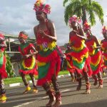
 Yospan dance is another dance originating from West Papua, this dance is an amalgamation of two traditional dances, namely Yosim dances originating from Sarera Bay (Serui/Yapen, Waropen) and Pancar dances originating from Biak, Numfor, and Manokwari. The musical instruments used for Yosim are usually Cuku lele (ukulele) and guitars, which shows foreign influences as these were not instruments from Papua. Included was also local bass made from three strings, with the strings made from pandan leaves. As well as Kalabasa, a dried calabash, which was then filled with beads.
In Yosim dance, the women are dressed with weavings to cover the chest, and headress made from bird feathers. While the men are bare-chested and wearing the same headress. The dance movement are more energetic though simple. In Pancar dance, the music are from Tifa drums which is the universal instruments for coastal Papuans. The drum skin is usually made from soa-soa (lizards). The movements are more stiff following the Tifa beats.
Yospan dance is another dance originating from West Papua, this dance is an amalgamation of two traditional dances, namely Yosim dances originating from Sarera Bay (Serui/Yapen, Waropen) and Pancar dances originating from Biak, Numfor, and Manokwari. The musical instruments used for Yosim are usually Cuku lele (ukulele) and guitars, which shows foreign influences as these were not instruments from Papua. Included was also local bass made from three strings, with the strings made from pandan leaves. As well as Kalabasa, a dried calabash, which was then filled with beads.
In Yosim dance, the women are dressed with weavings to cover the chest, and headress made from bird feathers. While the men are bare-chested and wearing the same headress. The dance movement are more energetic though simple. In Pancar dance, the music are from Tifa drums which is the universal instruments for coastal Papuans. The drum skin is usually made from soa-soa (lizards). The movements are more stiff following the Tifa beats.
 Movements include Seka, this dance movement are usually from southern coast with famous version from Kaimana, Fakfak, and Timika. In Pacul Tiga, or Pancar Meneru the dancer swing forward three steps, and throw both arms and one leg to the left and right, which was then repeated for the other leg. Jef movements are influenced by rock and roll dance from 1969 to 1971, Gale-Gale movements are from Wondama Bay and Mor-Mambor islands. Pancar movements are performed by the dancers move in a circle. These movements was inspired by animals, and have four variations.
Suanggi dance is also another dance from the regions around Cendrawasih Bay on the northern coast of New Guinea. This dance is basically an exorcism ritual by a bereaved husband after his wife becomes the victim of possession by mythical creatures (angi-angi). Suanggi is an evil spirit that wanders the earth because it cannot find peace and will take possession of a woman. The dance is usually only performed when death victims are found, which prompts the tribal leaders to initiate the ritual before the tribe members start the dance.
Movements include Seka, this dance movement are usually from southern coast with famous version from Kaimana, Fakfak, and Timika. In Pacul Tiga, or Pancar Meneru the dancer swing forward three steps, and throw both arms and one leg to the left and right, which was then repeated for the other leg. Jef movements are influenced by rock and roll dance from 1969 to 1971, Gale-Gale movements are from Wondama Bay and Mor-Mambor islands. Pancar movements are performed by the dancers move in a circle. These movements was inspired by animals, and have four variations.
Suanggi dance is also another dance from the regions around Cendrawasih Bay on the northern coast of New Guinea. This dance is basically an exorcism ritual by a bereaved husband after his wife becomes the victim of possession by mythical creatures (angi-angi). Suanggi is an evil spirit that wanders the earth because it cannot find peace and will take possession of a woman. The dance is usually only performed when death victims are found, which prompts the tribal leaders to initiate the ritual before the tribe members start the dance. 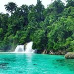
Fak Fak
Kaimana
Manokwari
Manokwari Selatan
Pegunungan Arfak
Teluk Bintuni
Teluk Wondama
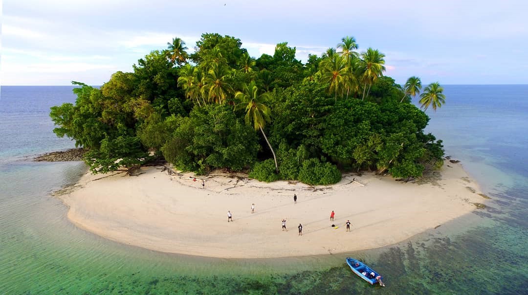
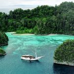
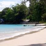
Teluk Cenderawasih National Park
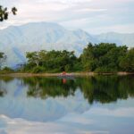
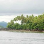
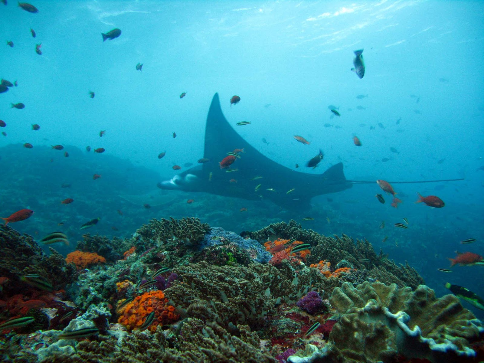
Teluk Cendrawasih national Park is the largest marine national park of Indonesia, located in Cenderawasih Bay, south-east of Bird’s Head Peninsula. It includes the islands of Mioswaar, Nusrowi, Roon, Rumberpon and Yoop. The park protects a rich marine ecosystem, with over 150 recorded coral species, for which it is considered a potential World Heritage Site.
Flora and fauna
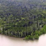
Extending over 14,535 km2, the national park includes coastal and mangrove ecosystems (0.9%), coral reefs (5.5%), island tropical forest ecosystems (3.8%), and marine waters (89.8%). Some 46 species of plant have been recorded on the islands, dominated by Bruguiera and Avicennia species, Nypa fruticans, Metroxylon sagu, Casuarina equisetifolia, and Terminalia catappa.
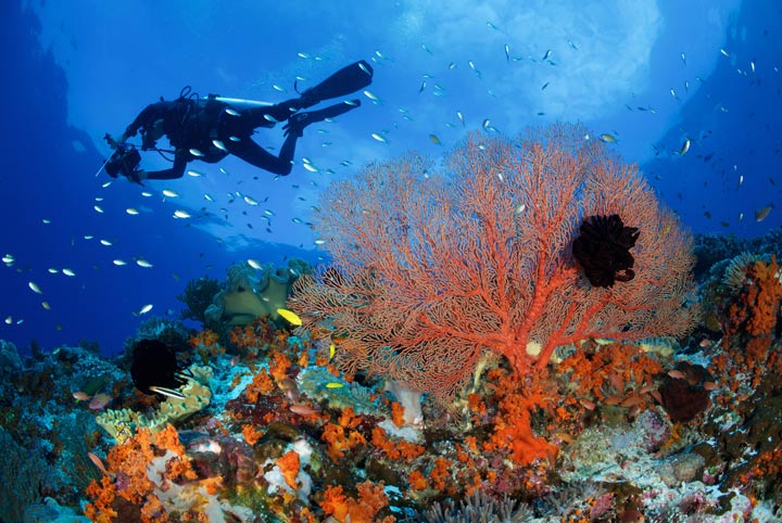
The coral reef ecosystem forms part of the Coral Triangle region. In the park, 150 species of coral have been recorded, consisting of 15 families and distributed on the shores of 18 islands. Among these are colonies of blue coral, black coral, Leptoseris species, Mycedium elephantotus, and Alcyonacea or soft corals. The percentage of live coral coverage varies from between 30-40% to 64-65%.
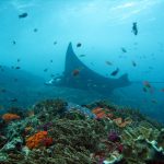

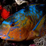
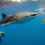
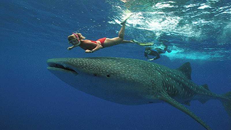 Over 200 fish species inhabit the park, among them butterflyfish, damselfish, parrotfish, rabbitfish, clownfish and sharks including whale sharks.
Species of mollusc include cowry, Strombidae, Lambis species, Charonia tritonis, and giant clam.
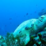
Four species of turtle are common in the park: the hawksbill turtle, green turtle, olive ridley turtle, and leatherback turtle. Mammals include dugong, blue whale and dolphins.
 Human and Conservation
About 14,000 people live in 72 villages within the park. Several Austronesian languages are spoken in the area, which form part of the Cenderawasih languages branch and include: Wandamen, Dusner, Meoswar, Roon and Yeretuar.
Most of the park is part of Teluk Wondama Regency of West Papua province, while the eastern part is in Nabire Regency of Papua province.
In 1990, the area was designated as Teluk Cendrawasih Marine Nature Reserve. The national park was designated in 1993 and declared in 2002. The park is managed by Balai Taman Nasional with a personnel of 106.